Thursday, December 31, 2009

End of the Year

It's been a while since any of us posted.

So, let's see... what has happened?

The usual. There have been band concerts. Boy Scout events. Snow. Hikes. Holidays. Lost teeth. Minor illnesses. All the usual. Good meals. Blooming plants. And so on.

Here are a few photos.


We had some early cold weather in October. All of the holiday cacti branches within two feet of the windows promptly set buds. And then bloomed.


The fuchsia-colored one in the photo above really bloomed its fool head off. I couldn't even count how many flowers there were on some of the branches.

The sides of the plants that were more than two feet from the windows didn't set buds then. We had another cold spell earlier this month. Now the closer side is setting buds. A few other plants that didn't get cold enough or dark enough back in October or November are also setting buds now. I expect we'll get a few more flushes of flowers through winter and into early spring.


Here's an orchid that was blooming earlier this year. It bloomed for a few months. We don't take very good care of our orchids. They still surprise us with pretty flowers every now and then.


The cats. We got them from a local shelter a few years ago. They had been together in their previous home. When we picked out one of the cats to take home, the staff asked us if we wanted both. We said yes.

They like to cuddle together sometimes, as you can see in the photo. Sometimes they get into a forcible ear-licking contest. That usually doesn't end well. Most of the time they're pretty mellow. They are excellent mousers, too.

And that's enough from me!

Monday, September 21, 2009

The Last Day of Summer

Is also the first day of snow.


And the first day with sub-freezing temperatures.

Friday, September 18, 2009

Autumn Traditions

It's only a few days until autumn.

The forecast includes snow.

As always.

(well, almost always.)

Sunday, September 13, 2009

Photos and Rambling

Fall is rolling in. Yesterday was cool and damp. This morning, there was fresh snow on Pikes Peak. The snow line is clearly marked.

As usual, thoughts turn to blogging when the weather changes.

Here are a few photos from the spring and summer.

This first photo was taken this past spring. I'm not totally sure where I was when I took it, but it looks like this is a view of Garden of the Gods from the south. I think I was in Red Rocks Canyon Open Space and thought the foggy view was a nice contrast to the red of the Fountain Formation. It's clearly from before the oaks leafed out in the spring, which probably puts it in April or possibly May, 2009.


This second photo is of some newly planted sedums. I went to a plant exchange. Skybird, a member of the Rocky Mountain Gardening Forum on Gardenweb, graciously brought some hardy sedums to share.

I planted them out carefully, and set them on our upper deck where they would be safe from extreme weather and the depredations of our vicious predators, namely the deer and rabbits.


The plants were gone the next morning, less than 12 hours after they went outside. Gone. Disappeared. Vanished. Completely gone, down to the ground, no sign they'd ever been there, only the identifying sticks left behind.

I suspect Alien Abduction.

Chances are that the vicious predator was some kind of squirrel or chipmunk. It's even possible that it was a bird, though they usually leave some kind of detritus when they nibble.

In any case, the sempervivums I got from the same exchange stayed indoors for the summer. I'm considering some kind of squirrel-proof cage to put them in after the weather cools, so they can color up a bit for winter.

This third photo is of part of our yard in mid-June. We had a cool, wet summer, and thus a very nice wildflower display. These are the small penstemons that bloom in early summer, probably Penstemon strictus.


This last photo is of sedums blooming at Loveland Pass. The elevation is nearly 12,000' above sea level. Even though it was the middle of August, the weather was quite brisk. The temps were in the low to mid 40s and the wind was chilly. We went for some short hikes at the pass and at other areas nearby.


And that's it for today's photos!

What else... EE still has some scouting and band photos to upload. We had a busy summer involving all the usual fun -- scouting, band camp, karate camp, pottery camp, swim lessons, playing with friends, fighting with siblings, reading zillions of books, playing too much 'puter, watching too much TV, hiking, biking, playing tourist, and everything else. We only had one or two weekend days free for the whole summer. Even now that school has begun, our weekends are still very busy.

We set up our big goldfish tank. One day we'll get photos of that uploaded. The cats are very fond of it. We often find one of them sitting on top of the tank in the morning, staring wistfully at the fish below. He used to dip his paws into the water, but we put something over the open area so that he could no longer go fishing. The fish seem oblivious to the cats. They sure notice us, though! That's because we feed them.

Saturday, September 12, 2009

Crestone Needle

Since we didn't complete all three peaks on the Aug 29 trip, Rick and I returned on Sept 10 with the summits of Crestone Needle and Humboldt Peak as our goal.

Again, we started out plenty early, meeting at IHOP at 3:30AM and starting the hike at 5:50AM. It started to get a bit light in the east around 6:30.


On the last trip, we climbed up Broken Hand Pass in the dark. This time it was light but that just kept reminding us of how much we had left to go. On the way up, Alpenglow on the face of Crestone Needle lit up the whole valley.


We got to the top of the pass and then headed along the back side of the ridge over to a couple of gullies where we made the final ascent. The gullies here were steeper but the rock was generally good and solid.


At the top of the gully, there is a short walk along the rugged summit ridge to the peak itself. This is Rick negotiating the last few hundred feet. Directly above his head is Broken Hand Peak.


We gained the summit at about 9:15AM and were the only ones there.


It was 11:30AM when we completed the descent back to Lower South Colony Lake. Then up the other side of the lake toward Humboldt Peak. Although not as tough a climb as the gully portion of Crestone Needle, a mile of negotiating a path through large boulders took its toll.


We finally gained the summit of Humboldt about 1:30PM. The weather was deteriorating so we didn't spend long up there, just long enough to find the summit log and the geocache. We got sprinkled with snow and rain on the way down, but there was no lightning.


A couple of other interesting sights -- some Rocky Mountain bighorn sheep and a nice fossil of a fern rounded out the day.


Crestone Peak

On Aug 29, I went with two friends to the Sangre De Cristo Wilderness to climb Crestone Peak, Crestone Needle, and Humboldt Peak. We met at an IHOP parking lot at 1AM and started hiking at 3:30AM. The "standard route" begins on the east side of the Sangre De Cristo mountain range, just south of the town of Westcliffe. The route leads past a couple of glacial lakes and over Broken Hand Pass, down the west side, then finally up the last 3000 feet to the summit through the "Red Gully."


It was dark until we got to the Red Gully; I took this photo of the pass on a different trip. The pass is that low notch in the rugged ridge between Crestone Needle on the right and Broken Hand Peak on the left.

The Red Gully is a slightly softer layer of rock that has formed into a small canyon. Most of the gully is solid rock but there are stretches where every step is on loose rock. It is a challenge to keep from knocking loose any rocks and endangering those below. Everyone we saw was wearing a climbing helmet.


At the top of the Red Gully, you come to a notch between East Crestone Peak on the right and Crestone Peak itself (from where the photo was taken). You can see my climbing partners in the center of this photo just as they reach the saddle. The other side (left) is a sheer 3000-foot cliff.


We finally gained the summit at around 9:15. This photo shows me, Rick, and Mark on the summit with Kit Carson Peak in the background.


By the time we got back down the Red Gully then back up to the top of Broken Hand Pass, weather was moving in so we decided to head back to the car.

Monday, July 20, 2009

Kit Carson summit

At 4:00 the next morning, we left the camp and followed the GPS track up the side of Challenger Point. We were close to the ridgeline at 13,200 feet by the time the sun came up. There was a cloud bank low in the east so the sunrise and alpenglow was not that good.

Soon after sunrise, this is the type of climbing we were doing.


We reached the ridgeline shortly after and the destination was in sight. The pyramidal one on the right is Challenger Point and the rounded one in the background on the left is Kit Carson Peak.


Looking back down the ridgeline from the summit of Challenger, Rick is negotiating the boulders.


We had a pretty good view of the Great Sand Dunes National Park down below. The dunes sure look small from up here.


From the top of Challenger, we got the first good look at "Kit Carson Avenue", a ledge in the middle of a 5000-foot high cliff. That's it there where the snow is. Following this ledge for a half mile around the back of the peak is the easiest way to the top.


It's a 600-foot descent to the saddle between Challenger and Kit Carson, then up the Avenue to a notch and down the Avenue on the back. The scale of things up here can fool you. What looks like a precarious ledge from a half mile away is actually no problem at all.


Around the back, Kit Carson Peak is not as steep, but still plenty rough going. This is a class 3 section which means hands are needed in places. If you're careful, you can avoid knocking loose rocks down on those following behind. Note everyone is wearing helmets.


After a half hour of that, we reached the summit!

I went with 2 friends to the Sangre de Cristo Wilderness to climb two of the 54 Colorado 14'ers (mountain peaks over 14,000 feet elevation), Challenger Point and Kit Carson Peak. It is a 5-mile hike into Willow Lake where we camped for the night.


Near the beginning.


The Colorado state flower was everywhere.


One of dozens of waterfalls as we gained the 2500 feet elevation to Willow Lake.

We arrived at the lake some 3 hours after leaving the parking lot, close to 7 PM. The lake is at one level of a cirque carved by a glacier. You can see one of the many stairsteps at the headwaters of the lake where the waterfall cascades some 200 feet down the cliff. We hiked on up to the top of the waterfall and camped there.


The entire mountain is made of this meta-conglomerate--fused matrix holding large chunks of rock in various colors. Most of these chunks are 2 to 4 inches across, but there were some that were 1 or 2 feet across.


It was getting close to sunset when we got to the top end of the lake.


We got camp set up, ate a sandwich and watched the sun set.


To be continued...

Sunday, June 14, 2009

Tonight's menu:

- Marinated boneless porkchops. Peach glaze.
- Fennel baked potatoes. Sliced fresh fennel bulb, potatoes, butter, salt, pepper.
- Vegetable, probably thin whole green beans.
- Homemade bread. We were almost out of flour so I had to improvise. White + wheat + rye + spelt = ?? I formed it into a focaccia-type shape topped with olive oil. On one half, I put shredded Parmiggiano Reggiano and sliced kalamata olives. Other half is unadorned.
- Columbia Crest Merlot.
- Dessert - Lemon-raspberry flan in individual ramekins.


Mom hasn't called so I assume she will be home for dinner. Of course, Imax and Copper have had the phone busy talking about runescape. No calls on my cell yet though.

Update...Mom just called and said they were going out with the karate gang and would not be home for dinner. Oh well, I guess we'll eat it without them. Which is better...the menu above or the Golden Corral ;-). I guess I'll save them some dessert since there's a ramekin with each of their names on it. The rest? We'll see...

Sunday, June 7, 2009

Imax (age 10) and I went to the Elephant Rock bike ride This morning. We took the 25-mile fat tire (off-road) route which turned out to be 29.8 miles, as reported by my GPS. We completed the course in a little over 4 hours--7:45 AM to 12:05PM--including breaks at the rest/aid stations. It's a great route through rolling hills and "horse country" east of Castle Rock--very green this year and spattered heavily with wildflowers.

One guy a couple of bikes behind us wiped out by running off the pavement into the gravel shoulder. We heard the crash. I looked back and a couple of people had stopped to help. The cyclist was up and walking around so nothing serious.

Elephant Rock is one of the 10 largest bicycle events in the country. They maxed out at 7000 riders across 5 different courses from 7 miles to 100 miles. Our house is just off the 100 mile course and when we came home there was still a solid line of bikes heading to Castle Rock, with about 30 miles left to go.

Tonight's menu, an old standby. Hungry but not ambitious.

- Meat loaf (family recipe)
- tater tots
- tossed green salad
- homemade yellow cake (made with Copper) to be topped with sliced fresh strawberries and a lemon sauce left over from a dessert last week.

Wednesday, June 3, 2009

Parmesan-sage pork chops

Tonight's menu:

Parmesan-sage boneless pork chops (adapted from http://www.epicurious.com/recipes/food/views/Baked-Pork-Chops-with-Parmesan-Sage-Crust-104711).

Diced potatoes and onions rolled in spices and baked

Broccoli with butter-garlic sauce

A nice vinho verde

fresh strawberries on ice cream

Wednesday, May 27, 2009


Tonight's menu: Marinated boneless pork chops with reduced wine sauce, potatoes (not sure what style yet), fresh braided bread (part whole wheat with olive oil, egg, and a touch of molasses), whole green beans with toasted almonds.

Friday, May 22, 2009

Band concert photos


Ian on clarinet, center right.


Roxanne is standing in the white top.


Roxanne is on the right.

Wednesday, May 20, 2009


Imax performed last night in a school concert. They play a few simple songs on recorders. That's him in the white shirt and green recorder.

Monday, May 11, 2009

Copper at her piano recital.

Bike/hike geocaching

A few pictures from Little Scraggy Peak and the Chairs of the Gods in the Buffalo Creek, CO area.


Monday, April 27, 2009

Scout campout

We went on a combined cub scout / boy scout overnight camping trip this weekend. The boy scouts were working on some kind of leadership badge that had them teaching something to cub scouts. We did softball, ultimate frisbee, fishing, and geology.


Marshmallows around the campfire.


Why did we bring a pink tent to a boy scout event??

Sunday, February 22, 2009

More mid-winter toddles

We're having another run of beautiful winter days, sunny and mild. So off we went to enjoy the outdoors. We had snow and cold temps on Friday evening. We were happy to see that Saturday's weather was nice enough for outdoor fun.

We went to the Boulder area. It's lower there than it is here, so there's less snow and ice on the trail. We also wanted to do some hiking associated with certain earthcaches. An earthcache is a non-physical cache with a geologic theme. Anyone can put one together. They are evaluated and approved by the Geological Society of America.

The prairie dogs were out today. They seemed to enjoy the sunny weather as much as we did. They were sunning themselves, running about, nibbling on weeds and seeds, barking, and so on.


The first little hike was along the Old Kiln Trail in the Foothills Trail Area. It's a short loop that goes past an old lime kiln and along the south side of a canyon cut by Four Mile Creek. The earthcache is actually a geology field guide, open to everyone. One claims the earthcache by doing a bit of extra work at a few of the sites in the guide.

The Old Kiln trail wanders through several important geologic units. It's a good way to see a lot of the local geology. Similar units occur up and down the Front Range region, including near the Palmer Divide. We saw most of the units from the time of the Lykins Formation through the Niobrara Formation and Pierre Shale. Some of these units yield interesting fossils, including dinosaurs. I don't think any dinosaur fossils have been found in this area, though.

The field guide points out interesting sedimentary structures in the rocks and interprets the environment the rocks were deposited in. Many are associated with water -- swamps, ocean bottoms, shorelines, rivers. The Lyons sandstone is usually thought to be wind-driven dunes.

We did not go down-section as far as the Fountain Formation, which is associated with the erosion of an ancestral Rocky Mountain Range. The famous Flatirons, a mountain ridge near Boulder, show off the Fountain Formation in this area. The Fountain Formation also makes up the geology of the Red Rocks Amphitheater, and is one of the prominent rocks in the Garden of the Gods park area. But I digress.

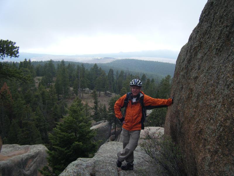
The photo above was taken from the Old Kiln Trail. It's a view across the road/creek to the next ridgeline to our north. We were walking through the same geologic units. This is the Dakota Hogback in this area. The Dakota Hogback is a ridge formed by tilted units in the Dakota sandstone. One finds ridges with these units paralleling the east side of the Rockies all the way through Colorado.

We were still psyched for more toddling after the first little hike, so off we went on another earthcache-related hike.

This next hike was at Marshall Mesa Open Space. Marshall Mesa is a pleasant park that's not up against the mountains the way that the first hike was. The rocks are not tilted as much. Most of the rocks here are younger than the rocks at the first place. The oldest is the Pierre shale, and then there are a couple of younger units. One of them, the late Cretaceous Laramie Formation, often contains coal in economically attractive quantities. Marshall Mesa was the site of coal mines in the late 19th and early-mid 20th centuries, part of the Boulder-Weld coalfield. The coal wasn't fantastic stuff, but it was good enough for the local markets.

As with the first earthcache, we followed a publicly available field guide to the geology of the park. The earthcache version was the same, with the addition of a few extra steps.

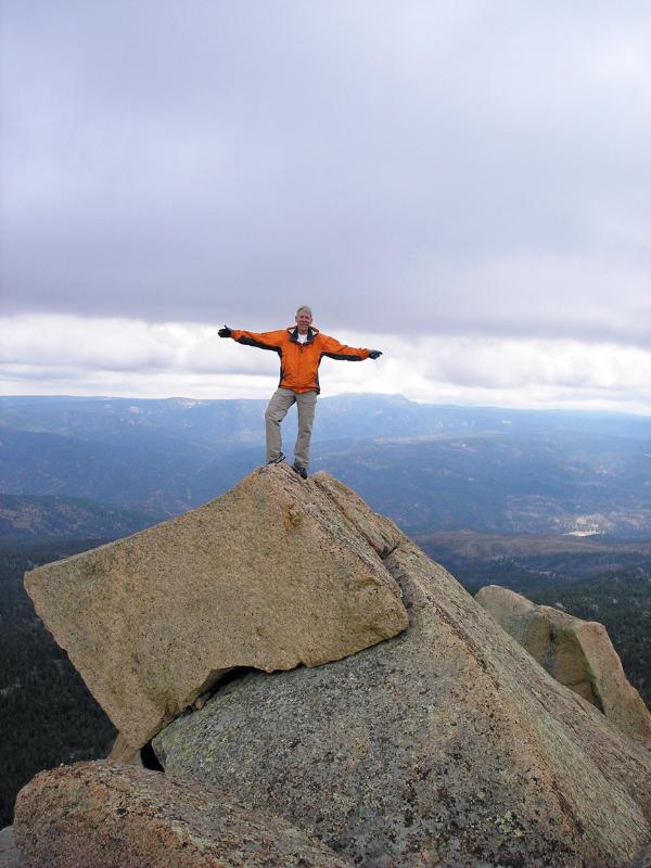
The photo to the right is part of the view from the parking lot. One sees a valley with old mining features and a lot of prairie dogs. Above it is a low mesa with trees. There are outcrops of the different units -- sandstones, mudstones, coal -- plus evidence of faults and other things of geologic interest (such as quartzite and meta-conglomerate rocks carried here from the high mountains by old rivers). Some of the outcrops are prominent, such as the ones in the hill in this photo, while others are subtle or not well exposed. You can't see it very well in this photo, but there are ditches running through the area, too. The whole vista is very tranquil, as is the hiking experience. The trails are gentle and wide.

I've been reading about the history of coal-mining in Colorado. This area really features a lot of the things I've read about. One can see mine subsidence collapse features, evidence of underground coal fires, and so on. The non-mining geology is just as interesting. I'd babble on about it for a while, but I wouldn't want any blog readers to hurt themselves from the resulting boredom-induced coma.

Coal mining in Colorado is part of the history of the labor movement in the US. Workers were not treated well. Unionization was slow and bloody. The Open Space people have made available a nice history of mining in the Marshall area.

---------------

Late winter is a great time for hiking at the lower elevations near here. The increasing daylength and higher sun angle actually melt some of the snow and ice. The vegetation isn't a problem. Stickery weeds from last year are knocked down, and the new growth hasn't started. Cacti are still dormant and not nearly as vicious. Rattlesnakes are still asleep. Mosquitoes and other bugs aren't really out yet. It's not too hot. The thunderstorm danger is minimal. Winter conditions can be avoided and/or planned for.

I love the quieter colors of this time of year. Without all the distracting greenery, one can see more details. There are plenty of critters that are still around, and they can be more easily seen and heard.